Welcome!
This website, created for the Appalachian Regional Commission by the University of Illinois at Urbana-Champaign Regional Economic Applications Laboratory and the Center for Regional Economic Competitiveness, provides diversity and demographic data for all 3,100+ U.S. counties. This site is based on research for and serves as a companion to the report "Economic Diversity in Appalachia: Metrics, Tools, Strategies and Guides." Use the buttons below for more information.
About this site Read the report Read the user guide
About the Diversity in Appalachia Web Site
The Diversity in Appalachia web tool includes data, indicators, and visuals designed to help practitioners and policy makers understand and explore several key concepts related to economic diversity. Through tables, charts, graphics, and maps, users are able to quickly and easily undertake selected analyses of the economies of all 3,100+ U.S. counties. A practitioner's guide has been developed to help users understand how the tool can be used to address commonly asked applied research questions.
This web tool was created for the Appalachian Regional Commission by the University of Illinois at Urbana-Champaign Regional Economic Applications Laboratory and the Center for Regional Economic Competitiveness.

About the Appalachian Regional Commission
ARC's mission is to be a strategic partner and advocate for sustainable community and economic development in Appalachia.
The Appalachian Regional Commission (ARC) is a regional economic development agency that represents a partnership of federal, state, and local government. Established by an act of Congress in 1965, ARC is composed of the governors of the 13 Appalachian states and a federal co-chair, who is appointed by the president. Local participation is provided through multi-county local development districts.
For more information about the Appalachian Regional Commission, please visit their web site at www.arc.gov.

About the University of Illinois at Urbana-Champaign Regional Economic Applications Laboratory
The Regional Economics Applications Laboratory focuses on the development and use of analytical models for urban and regional forecasting and economic development for public policy decision making and for strategic private sector marketing. REAL develops comprehensive state and metropolitan models that integrate econometric and input-output analysis to provide for both impact and forecasting analyses.
For more information, visit www.real.illinois.edu.

About the Center for Regional Economic Competitiveness
The Center for Regional Economic Competitiveness (CREC) was established as a not-for-profit 501(c)3 organization in 2000 to provide research, training, and technical assistance to regions seeking to use fact-based analysis to help design and implement innovative job creation strategies in a knowledge-driven economy. Through its technical assistance and research efforts, the Center helps leaders and organizations to understand the economic forces impacting their regions and their individual roles and responsibilities in promoting economic prosperity. CREC also assists these community stakeholders in formulating transformational strategies to build sustainable regional growth.
For more information, visit www.creconline.org.
Data Sources
- 2012 Population
- U.S. Census Bureau Population Estimates by County, July 1, 2012
- Population Change, 2009-2012
- U.S. Census Bureau Population Estimates by County, July 1, 2009 & 2012
- 2012 Employment and Earnings
- Complete employment and earnings estimates by industry, Economic Modeling Specialists, Intl, quarter 3 data release, 2012
- Employment Change, 2009-2012
- Complete employment and earnings estimates by industry, Economic Modeling Specialists, Intl, final data release 2009 & quarter 3 data release, 2012
Definitions
Diversity
-
- Industry Diversity
- Using 1,110 industry types categorized according to the North American Industry Classification System (NAICS), industry diversity measures the number of industry types in a region and the evenness of employment across the industry types that employ a region's residents. Low industrial diversity implies employment concentrated in only a few industry types, while high industrial diversity implies employment distributed relatively evenly across many industry types.
- Function Diversity
- Measures the evenness of employment across eleven broad industry categories or economic functions. Economic functions are delineated by grouping NAICS industries together into one of eleven functional categories (see Industry Functions). These functions include industries that are broadly similar on factors such as inputs, outputs, and/or the technological or skill requirements necessary to perform the work customary to these industries. Industries that tend to serve primarily local markets, such as retail trade, local government, and consumer banking, are not included in these functional economic categories. Low functional diversity implies employment concentrated in only a few economic functions, while high functional diversity implies employment distributed relatively evenly across many functional economic categories.
- Occupation Diversity
- Using the 96 minor occupational groups defined in the 2000 Standard Occupational Classification (SOC), occupation diversity measures the number of occupation types with employment in a region and the evenness of employment across all occupations in a region. According to the Bureau of Labor Statistics, occupations are grouped based on similarity of "work performed, skills, education, training, and credentials." Example occupational groups include agricultural workers, life scientists, secretaries and administrative assistants, and top executives. Low occupation diversity implies employment concentrated in only a few occupational groups, while high occupation diversity implies employment distributed relatively evenly across many occupational groups.
The Appalachian Region
- The Appalachian Region, as referred to in this site, is defined by the Appalachian Regional Commission's authorizing legislation as a 205,000-square-mile region that follows the spine of the Appalachian Mountains from southern New York to northern Mississippi. For more details about the Appalachian Region, click here.
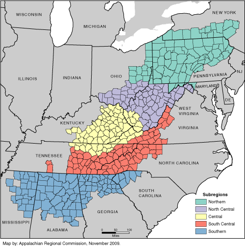
The Appalachian Regional Commission Subregions
-
The Appalachian subregions are contiguous regions of relatively homogeneous characteristics (topography, demographics, and economics) within Appalachia. For more details about the Appalachian Regional Commission Subregions, click here.
Appalachian Regional Commission Economic Status, FY 2013
-
The Appalachian Regional Commission compares economic data for each county in the Appalachian Region to national economic data. The economic status represents the condition of the county's economy in relation to the national economy. Since this indicator is calculated by the Appalachian Regional Commission for Appalachian counties, counties outside of the Appalachian Region do not have an economic status.
Find more detailed information about these designations here.
- Distressed
- Distressed counties rank in the worst ten percent of U.S. counties when jointly considering the three-year average unemployment rate, per capita market income, and poverty rate.
- At-Risk
- At-risk counties rank between the worst ten percent and 25 percent of U.S. counties when jointly considering the three-year average unemployment rate, per capita market income, and poverty rate.
- Transitional
- Transitional counties rank between the worst 25 percent and best 25 percent of U.S. counties when jointly considering the three-year average unemployment rate, per capita market income, and poverty rate.
- Competitive
- Competitive counties rank between the best ten percent and 25 percent of U.S. counties when jointly considering the three-year average unemployment rate, per capita market income, and poverty rate.
- Attainment
- Attainment counties rank in the best ten percent of U.S. counties when jointly considering the three-year average unemployment rate, per capita market income, and poverty rate.
County Character
-
For more information about these definitions, see Isserman, A M, "In the National Interest: Defining Rural and Urban Correctly in Research and Public Policy", International Regional Science Review 28: 465-499 (2005).
- Rural
- A rural county has 1) a population density less than 500 people per square mile and 2) at least 90 percent of its population in Census-defined rural areas or no Census-defined urban areas with at least 10,000 people.
- Mixed Rural
- A mixed rural county has 1) a population density less than 320 people per square mile and 2) less than 90 percent of its population is in Census-defined rural areas.
- Mixed Urban
- A mixed urban county has 1) a population density of 320 people per square mile or higher and 2) less than 90 percent of its population in Census-defined urban areas.
- Urban
- An urban county 1) has a population density of at least 500 people per square mile, 2) at least 90 percent of its population in Census-defined urban areas, and 3) its population in Census-defined urbanized areas is at least 50,000 or 90 percent of its total population.
Similar Counties
-
These are the five most similar counties to the county of interest when considering total population in the county and surrounding region, county land area, the share of income and earnings in various income sources and industries, and rates of educational attainment and poverty.
To enable benchmarking, a county's similar counties were identified with the use of a Mahalanobis distance metric applied to 16 economic, demographic, and location variables. The Mahalanobis indicator was calculated for all pairs of US counties, and it essentially measures the difference or "distance" between county pairs when considering these 16 variables. For each county, the counties with the five lowest distance indicator values were identified as matches. Some US counties are highly unique and the quality of matches is relatively low. A county that is identified as a "weak" or "very weak" match to another county is probably only similar to the first county on one or a few of the economic, demographic, and location characteristics. Counties with no listed matches did not have available data for all the 16 variables. The following variables and data sources were used to determine similar counties:
- Per capita income, 2011, Bureau of Economic Analysis, Local Area Personal Income and Employment.
- Percent of income by source, 2011, Bureau of Economic Analysis, Local Area Personal Income and Employment.
- Percent from farming income
- Percent from dividends, interest, and rent income
- Percent from proprietors income
- Percent of earnings by industry, 2012, Economic Modeling Specialists International (see industry function definitions for more details)
- Percent from mining earnings
- Percent from capital-intensive manufacturing earnings
- Percent from engineering-intensive manufacturing earnings
- Percent from finance, insurance and real estate earnings
- Percent from corporate management & administration earnings
- Percent from government earnings
- Percent from knowledge-intensive business services earnings
- Population and area characteristics
- Total Population, 2010, US Census Summary File 1
- Square Miles in Land Area, 2010, US Census
- County distance in miles from an urban area with more than one million population, 2010, US Census Urban Area Boundary File. Note: Distance measured from county center to closest edge of urban area.
- Percent of population 25 years or older with at least a high school degree, 2007-2011 American Community Survey, US Census Bureau
- Percent of population below poverty level for the population for which poverty status is determined, 2007-2011 American Community Survey, US Census Bureau
Industry Function/Industry Function Specialization
-
The industry functions are defined by grouping industries together into one of the eleven functional categories defined below, with each category representing industries that are broadly similar on factors such as inputs, outputs, and/or the technological or skill requirements necessary to perform the work customary to these industries.
Industry Function Specialization:
A county's industry function specialization represents its largest specialization relative to the share of US employment accounted for by each of the industry functions. Industry function specialization was determined by comparing county employment in each functional category to the average national employment in each category. For each county, the industry function specialization was assigned to the function with the largest positive difference between actual county employment (i.e., the totals reported in the 2012 EMSI data) and expected county employment (i.e., the level of county employment in a functional category if this category accounted for the same percentage of county employment as it did for US employment).
- Agriculture & Natural Resource Extraction
- Industries related to agriculture, forestry, fishing, and mining.
- Capital-Intensive Manufacturing
- Manufacturing industries that tend to be resource-, capital-, and labor-intensive. Example industries in this grouping include food manufacturing, paper manufacturing, iron and steel mills, automobile manufacturing, and textile mills.
- Corporate Management & Administration
- Establishments that manage, administer, or hold a controlling interest in companies.
- Distributive Services
- Industries related to transportation, wholesale trade, telecommunications, and utilities.
- Engineering-Intensive Manufacturing
- Manufacturing industries that tend to employ a significant number of engineers and scientists. Example industries in this grouping include petrochemical manufacturing, refineries, computer manufacturing, and aircraft manufacturing.
- Finance, Insurance & Real Estate
- Industries related to finance, insurance, and real estate.
- Government
- State or federal governments. This category excludes any local government employment, as well as employment related to education or hospitals.
- Health care
- Hospitals, medical laboratories, and nursing care facilities.
- Higher Education
- Colleges, universities, and professional schools.
- Knowledge-Intensive Business Services
- Industries related to professional, scientific, and technical services, including legal, accounting, design, research and development, and advertising services.
- Media, Entertainment & Recreation
- Industries related to broadcasting, publishing and media production, and arts, entertainment, and recreation activities, including casino hotels.
Occupational Knowledge Cluster
-
The occupational knowledge clusters are 12 groups of occupations categorized based on similarities in the knowledge required to work in these professions. Clusters were identified using procedures detailed in Feser (2003). US Department of Labor Occupational Information Network (ONET) data on type and level of knowledge required to work in professions were used to derive 12 clusters of occupations. Data from the Bureau of Labor Statistics' national Staffing Pattern Matrix were used to translate county employment by industry data to county-level employment by knowledge cluster. Employment in government industries, including military employment, is not accounted for by these knowledge clusters. The descriptions below provide examples of common occupations and average education or training levels associated with the 12 knowledge clusters.
Occupational Knowledge Cluster Specialization:
A county's occupational knowledge cluster specialization represents its largest specialization relative to the share of US employment accounted for by each of the clusters. Occupational knowledge cluster specialization was determined by comparing county employment in each cluster to the average national employment in each cluster. For each county, the occupational knowledge cluster specialization was assigned to the cluster with the largest positive difference between actual county employment and expected county employment (i.e., the level of county employment in a cluster if this cluster accounted for the same percentage of county employment as it did for US employment). *Note: nearly 75% of counties have a specialization of "skilled, semi-skilled labor & machine operation" or "semi-skilled service".
- Agricultural & Life Sciences
- Common professions in this cluster include veterinarians, veterinary assistants and technicians, medical and clinical laboratory technicians, and supervisors of farming, fishing, and forestry workers. On average, these jobs require just over 3 years of post-secondary education — the 3rd highest average among the 12 knowledge clusters.
- Arts, Entertainment & Spectator Sports
- Common professions in this cluster include photographers, musicians, actors, writers, fine artists, and reporters. On average, these jobs require just less than 2 years of post-secondary education — the 7th highest among the 12 knowledge clusters.
- Construction & Specialized Mechanical
- Common professions in this cluster include carpenters, maintenance workers, construction laborers, and automotive service technicians and mechanics. On average, these jobs require less than 1 year of post-secondary education — the 10th highest among the 12 knowledge clusters. The average length of on-the-job training required for these professions is the 2nd highest among the clusters.
- Education, Counseling & Therapy
- Common professions in this cluster include teachers, fitness trainers, clergy, physical therapists, and social workers. On average, these jobs require nearly 3.5 years of post-secondary education — the highest average among the 12 knowledge clusters.
- Engineering, Architecture & Natural Resource Science
- Common professions in this cluster include civil, mechanical, and industrial engineers, electricians, architectural drafters, architects, and chemists. On average, these jobs require approximately 3.25 years of post-secondary education — the 2nd highest average among the 12 knowledge clusters. The average length of on-the-job training required for these professions is the highest among the clusters.
- Information Technology & Communications
- Common professions in this cluster include computer support specialists, software engineers, systems analysts, and database and network administrators. On average, these jobs require just less than 3 years of post-secondary education — the 4th highest average among the 12 knowledge clusters.
- Legal, Clerical & Administrative
- Common professions in this cluster include office clerks, cashiers, bookkeepers, secretaries, lawyers, and financial advisors. On average, these jobs require just over 1 year of post-secondary education — the 8th highest among the 12 knowledge clusters.
- Management & Finance
- Common professions in this cluster include general managers, accountants, first-line supervisors, real estate agents, and securities sales agents. On average, these jobs require nearly 2.5 years of post-secondary education — the 6th highest average among the 12 knowledge clusters. The average length of on-the-job training required for these professions is the 3rd highest among the clusters.
- Medical Science & Health Services
- Common professions in this cluster include nurses, nursing aides, physicians, dental assistants, and pharmacists. On average, these jobs require just over 2.5 years of post-secondary education — the 5th highest average among the 12 knowledge clusters.
- Semi-Skilled Service
- Common professions in this cluster include retail salespersons, customer service representatives, waiters and waitresses, stock clerks, child care workers, and food preparation workers. On average, these jobs require less than 1 year of post-secondary education — ranking 9th among the 12 knowledge clusters.
- Skilled, Semi-Skilled Labor & Machine Operation
- Common professions in this cluster include janitors, laborers, landscapers and groundskeepers, farmworkers, and welders. On average, these jobs require less than 1 year of post-secondary education — ranking 11th among the 12 knowledge clusters.
- Transportation, Distribution, Law Enforcement & Safety
- Common professions in this cluster include truck drivers, security guards, and pilots. On average these jobs require less than 1 year of post-secondary education — the lowest average among the 12 knowledge clusters.
Commuting Shed
-
A county's commuting shed includes all those counties that account for a significant share of the journey-to-work commuting flow headed toward or away from that county. Journey-to-work data from the U.S. Census Bureau's 2006-2010 American Community Survey were used to determine membership in a commuting shed. Specifically, counties are included in a commuting shed if they account for at least five percent of the worker flow toward or away from the county in question. Commuting sheds range in size from one to nine counties in size, including the county of interest. In order to calculate measures of commuting shed diversity, employment by industry data for all counties in a commuting shed were combined.
Development District
-
Development districts are regional development organizations that perform a variety of planning or economic development activities across county boundaries. Common names for these organizations include Councils of Government, Economic Development Districts, Local Development Districts, and Regional Planning Commissions. Databases from the National Association of Development Organizations and the Appalachian Regional Commission were used to determine county membership in development districts. In order to calculate measures of development district diversity, employment by industry data for all counties in a development district were combined.
Methodology
[Methodology info go here]